THE HISTORY OF EDISON PARK

THE EARLY YEARS

In 1866, the first two pioneer families arrived in southwest Florida at the southern bank of the Caloosahatchee River. They took cool refuge within the confines of a fort outpost that had been abandoned by the Union Army after the Civil War. The large compound would evolve to one day become the city of Fort Myers.

The elder of the group was Captain Manuel Alejandro Gonzalez, a Spanish sailor bound from Key West and already familiar with the Florida coastal terrain of sand, swamp, palm trees and scrub vegetation. His wife, Evelina Weatherford Gonzalez, soon became Fort Myers’ first school teacher, holding classes for four students within her temporary fort home.

The Homestead Act of 1862 meant that settlers could claim 160 acres of surveyed federal land and either buy the land outright or “prove up” after five years of occupation and improvement. However, due to strife during the Civil War, the survey team did not reach the southern bank of the Caloosahatchee until February, 1872. The following month, Captain Gonzalez and his family became Fort Myers’ first permanent settlers by claiming a large tract of land one mile south of “town” on what was considered one of the finest pieces of riverfront property. For official surveyed mapping, it is described as the “southwest quarter of Section 23”.

Running through the middle of his new homestead was a quarter length of a winding creek. The Captain aptly named it “Gonzalez Creek”. Several years later, it was renamed “Manuel’s Branch” , as we know it today. The Gonzalez home was built on its northern edge in the current Sandra Drive area just off of McGregor Boulevard. The family remained at their homestead for 25 years, until the late 1800’s when they moved back into town. (Click for photo in archives of remains of their settlement site - labeled - along Manuel’s Branch and the future Sandra Drive.)

In 1878, Howell A. Parker, a Civil War veteran and school teacher from North Carolina, arrived in Fort Myers to secure an appointment as a school principal, the first in the county. A year later, he was appointed Fort Myers’ first Postmaster and in 1885, was elected Fort Myers’ first mayor.

In 1879, Parker bought for speculative development a 160-acre tract of land located just east of the Gonzalez homestead. The tract, for which Parker paid 80 cents per acre, had been recently deeded by the Federal Government to the State of Florida and was described as the “southeast quarter of Section 23”. By the next 50 years, this tract and a 7-acre portion of the Gonzalez tract, would become Edison Park.

For our current-day reference, the Parker tract boundary ran east from Manuel’s Branch near Cortez Boulevard to Cleveland Avenue, then straight north to Edison Avenue, then west to the future fountain entrance at McGregor Boulevard (plus an adjacent one-acre lot), then straight south to the Branch again. It is perhaps ironic - or maybe by design - that the fountain entrance to Edison Park sits at the exact center of Section 23.

Through the years, many other speculators bought and sold Parker’s vacant quarter section. During one three-year period, there was a succession of four notable owners: (1909) retired New York State Senator Charles A. Stadler, nationally known millionaire who, in 1925, built one of Fort Myers’ finest riverfront homes on his “Seminole Grove” estate at the end of Gasparilla Drive; he was also the developer of the adjacent Seminole Park, an upscale subdivision (now Local Historic District), which lies along McGregor Boulevard south of Edison Park; (1911) John Morgan Dean, notable local builder of the Dean Hotel, and also the developer of the Dean Park subdivision (now on the National Register of Historic Places), which is just east of Downtown Fort Myers and; (1912) Fort Myers Development Company, Inc., made up of prominent local business men, which included Dean and also Frank C. Alderman, Sr., an attorney and banker.

FAMOUS NEIGHBORS

In 1885. the scantily populated “cow town” of Fort Myers was finally put in the limelight when Thomas Alva Edison, by then world famous, purchased a 13-acre riverfront parcel from local cattle baron Samuel Summerlin. Only a mile from town and with an abundance of wild bamboo (Edison’s newest filament in his light bulb prototypes), the site was deemed an ideal spot on which to build a winter home and laboratory. Edison’s long-time friend and business partner, Ezra Gilliland, joined in the purchase of 3+ of the 13 acres. Edison, a botanist as well as inventor, and his groundskeepers turned the property into a tropical paradise. “Seminole Lodge”, as Edison named it, soon became known as the largest experimental garden in the western hemisphere.

Riverside Avenue, a sandy road used as a cattle trail between Punta Rassa and Fort Myers, divided Edison's property. One half, the location of his laboratory and experimental garden areas, was just north of the Parker tract. The other half sat along the river, just north of the former Gonzalez homestead. There, Edison and Gilliland built their identical “pre-fabbed” homes side-by-side - barely in time for Edison to bring his bride, Mina, to honeymoon in Fort Myers. The Edison and Gilliland partnership eventually ended due to a bad business dealing and the Gilliland property went up for sale.

In 1892, Ambrose McGregor, a wealthy oil baron from Cleveland, purchased Gilliland’s property as his family’s winter home. Edison bought it back after McGregor’s untimely death in 1900. Riverside Avenue would later be paved and renamed “McGregor Boulevard” (1912) to honor Ambrose and his wife Tootie for their many civic contributions. Today, McGregor Boulevard is a state-designated historic highway, famous for the many towering royal palms Edison commissioned to be planted along it, just after McGregor’s death. The stately entrance to Edison Park evolved in this setting, along the Boulevard’s palm-lined vistas and adjacent to Edison’s tropical estate.

Over the next 45 years (minus a 14-year hiatus to early 1901), the Edisons’ hospitality and the warmer climate would bring their close friends, many of them famous, to vacation in Fort Myers. Automaker Henry Ford was one such friend. Just two years after his first visit in 1914, he and his wife Clara bought a 3-acre estate next door to the Edisons.

Through the late 1920’s, Henry Ford would take brisk morning strolls through the sparsely developed Edison Park subdivision. A favorite resting spot was the low south wall of the Edison Park archway entrance. From this congenial vantage point, Ford could admire his home across the Boulevard, amused to sometimes see curious passersby peering over the picket fence along his front yard.

Having these two world famous men living in Fort Myers brought precious publicity to the area, just in time for Florida’s “Big Boom”.

FLORIDA’S BIG BOOM

The “Big Boom” was a real estate phenomenon resulting from the public’s financial reserves profitted during and after World War I. It was the early 1920’s; there was money to spend and places to spend it. Like a gold rush, a flood of home seekers and developers headed to sunny Florida where land was not so much as cheap as it was attractive and available.

DEVELOPMENT BEGINS

On March 2, 1925, C. Perry Snell, a major pioneer developer from St. Petersburg, and his brother, local attorney Getty E. Snell, purchased from Fort Myers Development Company the quarter section once belonging to Parker; also, the future Sandra Drive area along Manuel’s Branch (Gonzalez homestead) and a one-acre triangular lot in the northern corner adjacent to McGregor Boulevard and Edison’s property.

The new property boundary was drawn up around a basic roadless plat of 34 rectangular lots averaging 5 acres each; all tolled, 168 acres. The Snell Brothers paid $500,000, or about $300 per acre. This was quite a sum compared to Parker’s 80-cents-per-acre governmental land purchase just 45 years prior, especially considering the land had remained virtually unchanged all of that time.

EP Early plat color.jpg

The Snell Brothers were already seasoned developers of several notable Fort Myers subdivisions such as Carlton Grove, just south of Manuel’s Branch, Valencia Terrace and Allen Park - all adjacent to each other. They began clearing and filling much of their newly envisioned development (click), reportedly spending as much as $1000 per acre for the work, when they offered a portion of it for sale.

On April 7, 1925, the “north one-third” was acquired by News Homes Development Company for approximately $2400 per acre. The company was soon headed by James D. Newton, a young man of 20 years, first arriving from Philadelphia in 1924 with door-to-door luggage sales in mind. Instead, opportunity as a developer and realtor blossomed. Newton had just completed Lovejoy Park on the south edge of downtown Fort Myers. This was a modest subdivision of cottage-size homes and duplexes, many with a stylish Mediterranean flavor. For first-time home buyers, Lovejoy Park was a popular place to live. Newton himself lived with his parents (Jane and Dr. Robley Newton) in one of the model homes on Katherine Street, next door to the notable architect who designed them - Nat Galliard Walker, and a few doors down from the leading contractor who built them - Howard L. Wheeler, of Wheeler Brothers Construction Company, comprised of Howard, Edward and Sherman “June”, Jr.

THE PLATTING

Soon after the partnership sale, the Snell brothers and Newton drew up a new plat of curved roads, lots and blocks - designed in the Snell tradition, yet innovative for its urban setting. They named their new subdivision “Edison Park” in honor of its famous neighbor. The plat was recorded with Lee County in January, 1926. The division of ownership followed the roadways; the land owned by New Homes Development Company included lots north of the center line of Ardmore Road and east to Cleveland Avenue. The Snells owned land south of Ardmore Road, plus the current Sandra Drive area. This gave New Homes Development a total of 55 acres and the Snells, a total of 113 acres. Most of the lots were for single-family homes while certain parcels along the eastern and northern boundaries were reserved for businesses, rental apartments and a planned elementary school.

Here is a link to a 1926 Sanborn Fire Insurance map showing the vacant land of Edison Park. https://www.loc.gov/resource/g3934fm.g3934fm_g012701926/?sp=1&r=0.044,0.657,0.497,0.297,0

From the late 1800’s to the 1970’s, the Sanborn Map Company depicted on their mappings the footprints of buildings and structures, and surveyed their exact locations, in order to allow fire insurance companies to assess their total liability in various U.S. urban areas. With the dawn of the satellite imagery/digital age, the maps are no longer used for underwriting. They do, however, help in historical research, especially in comparing changes to the built environment.

Shown below is the Edison Park plat as it was filed with Lee County in January 1926. (Some notations were not on the original):

EP Plat1.jpg

For New Homes Development Company, a deed of restrictions was filed which stated that …“all buildings are to be of Moorish, Spanish and Italian architecture… or an American modification”. Later, the deed restrictions were amended to include “variations in harmony with the surroundings”.

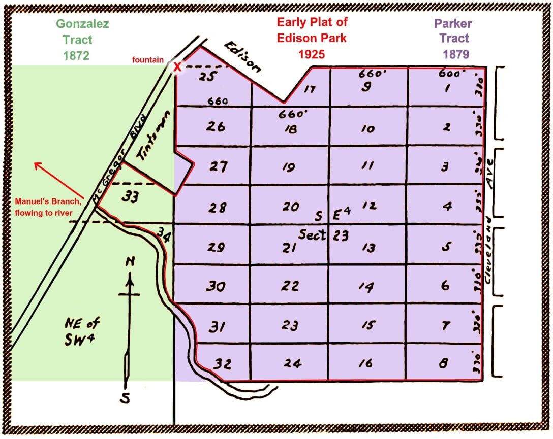
The map below is a close-up of the northern one-third of Edison Park, as copied from a 1940’s “Title Abstract”, the pre-digital-age method of tracking and recording the history of property ownership:

EP+Partial+map.jpg

To view a selection of pages of a Title Abstract from the Sandra Drive area, click here (soon!).

Further development of the Snell property south of Ardmore Road was delayed while the Snell brothers, Perry and Getty, attended to their other developments nearby and in St. Petersburg. However, with the unforeseen Depression Era looming, Snell land, and eventually most of New Homes land, would remain vacant until World War II. Until then…

CONSTRUCTION BEGINS

Almost immediately, New Homes work crews descended upon the area nearest McGregor Boulevard and Edison’s estate. Land clearing, infrastructure grading and model home construction began to turn the once primitive landscape into what would later become an exclusive and charming neighborhood. Within a short time, roads north of Ardmore Road were installed using crushed shells over a compacted sand base.

To paraphrase a James D. Newton Realty Company brochure of 1926: “Newton designed his tract under a novel plan which guarantees that every owner will have improved streets [using penetration asphalt], curbing 12 to 14 inches high, [perhaps to accommodate the high running boards of the Model-T], sidewalks six feet wide, city water and sewers, electricity, gas, ornamental street lighting and the most beautiful of landscaping.” Even the street sign design was ornamental, displaying the street name on a fluted concrete post from which hung a curly metal bracket holding a diamond-shaped “Edison Park” sign plaque. The 23 silver-painted cast iron Arcadian-style street lights - with frosted acorn globes - were the same design standard that lit up First Street, Hendry Street and others in downtown Fort Myers during that time.

(Click below and enjoy the scroll… to view a digitalized marketing brochure of 1926 - maintained and cataloged by the University of Florida): "Edison Park: A Name that Speaks for Itself… It is actual, tangible PROGRESS that counts."

With this brochure clever wording, James Newton, in his marketing hat, aimed to distinguish Edison Park's quality development from the flood of “fly-by-night” developments, in order to gain a vote of confidence from would-be buyers and investors.

By the end of 1926, many of the promised amenities, with the addition of telephone lines, were in place along the following streets: Menlo Road, Marlyn Road, Monte Vista, and parts of Euclid Avenue, Street lights dotted a route from Cortez to Monte Vista to Marlyn to Menlo to Llewellyn - between Cleveland Avenue and McGregor Boulevard.. These were standard Boom Time street lights, which also dotted Downtown Fort Myers along First Street and Hendry Street. They were eleven feet tall, with a fluted, 8-sided cast iron “Arcadian” light post, topped by an “acorn” globe. On February 20, 1927, local newspaper accounts of the official flipping-the-switch lighting dubbed the route “The Great White Way” because it was the only lighted roadway between these two important corridors.

Side Note: Over the next many decades, damaged street lights (converted from standard incandescent to sodium lights over the years) were removed and not replaced. By 2016, only 16 of the 23 originals remained. At the time, they were considered by Florida Power & Light Company to be the oldest surviving public utility street lights in all of Florida, having remained in their original locations and in continuous public utility service (apart from brief outages) for ninety years. However, due to maintenance costs and the need for additional lighting throughout the Edison Park Historic District, the City, and the neighborhood as surveyed, decided to let go of these notable, historic relics - but not the past.

In October 2017, through a Special Assessment 50/50 funding program, the original remaining lights were moved to City storage, and 80 modern LED street light replicas were finally installed throughout most of Edison Park. Included were new, attached street signs at each intersection, displaying the street’s name and an “Edison Park” placard - very similar to the 1926 original design. It was back in 1998, when the proposed replica street lights and signage (along with specific curbing type and sidewalk dimensions) were deemed by the Fort Myers Historic Preservation Commission to be the official public utility design standards of the Edison Park Historic District.

Aninteresting, very similar story, in Coral Gables, FL, is linked here > https://www.historiccoralgables.org/the-gables-arcadians-return-home/

DEDICATION AT THE FOUNTAIN

On April 7, 1926, exactly one year after the sale to New Homes Development, the fountain on McGregor Boulevard, Edison Park’s main entrance, was dedicated in a grand ceremony witnessed by a large crowd of townfolk and newsman. Seated on the speakers’ platform were Mina and Thomas Edison, James Newton, the Snell brothers C. Perry and Getty E., Fort Myers’ Mayor O. M. Davison and retired New York State Senator Charles A. Stadler, developer of 2 local subdivisions Seminole Park (now local Historic District) and the Stadler Subdivision - both south along McGregor Boulevard. In 1925, Stadler himself had built a massive home along the Caloosahatchee River.

Zoom in below to see the progression of homes built (and demolished!) during the various time periods and their significance to the development of Edison Park.

EP progress map1.jpg

Here is a link to Aerial photos of 1943-44: https://ufdc.ufl.edu/UF00071762/00003/images/81

The photo appears to show a CRATER in the middle of a developed area of Fort Myers. THAT is Edison Park, only partially developed - 18 years after its famous Grand Opening (April 7, 1926) - but then on the verge of its Post-War Building Boom. Cortez Blvd. was soon constructed, connecting future Edison Park roads, like Llewellyn Dr. and Columbus St., with the new hospital, high school and neighborhoods south of Edison Park. To see a close-up of the “crater” then - and now - click the “ARCHIVES” button at the main menu and scroll through the photos. It is unmistakable.

MORE TO COME… including the story of The Fountain Maiden - well known as Aphrodite, or “The Spirit of Fort Myers”, or Rachel at the Well For now, here is the patent, filed in 1920, that guided her construction and sculpting.